| property_id |
|
By default, shortcode uses current property for showing map. But if you want to show another property or use shortcode on non-property page you can use attribute property_id. Example: [property_walkscore_neighborhood property_id=777]. |
| ws_lat |
|
Latitude. you are able to use custom coordinates instead of property_id.
See example below. |
| ws_lon |
|
Longitude. you are able to use custom coordinates instead of property_id.
Example: [property_walkscore_neighborhood ws_lat="37.720309" ws_lon="-122.390668"] |
| ws_width |
100% |
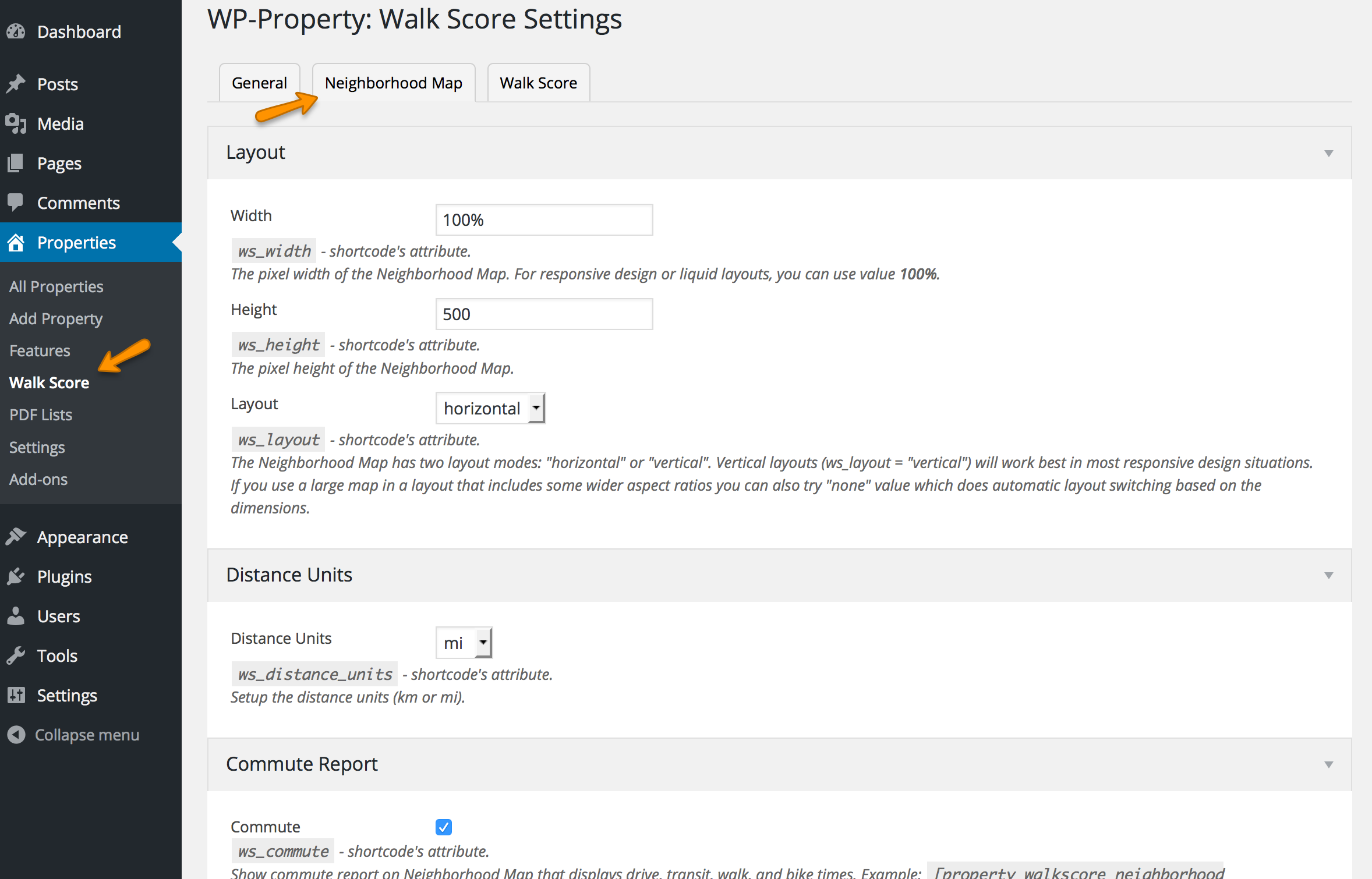
Width. The pixel width of the Neighborhood Map. For responsive design or liquid layouts, you can use value 100%. |
| ws_height |
400 |
Height. The pixel height of the Neighborhood Map. |
| ws_layout |
horizontal |
Layout. The Neighborhood Map has two layout modes: "horizontal" or "vertical". Vertical layouts (ws_layout = "vertical") will work best in most responsive design situations.
If you use a large map in a layout that includes some wider aspect ratios you can also try "none" value which does automatic layout switching based on the dimensions. |
| ws_distance_units |
mi |
Distance Units. Setup the distance units (km or mi). |
| ws_commute |
|
Commute. Show commute report on Neighborhood Map that displays drive, transit, walk, and bike times. Example: [property_walkscore_neighborhood ws_commute="true"] |
| ws_commute_address |
|
Commute Address. Optional. Specify a pre-determined destination address for the commute. Example: [property_walkscore_neighborhood ws_commute_address="3503 NE 45th St Seattle"] |
| ws_default_view |
|
Default View. Set the initial tile view. Available values: "commute" |
| ws_industry_type |
residential |
Industry Type. Choose which set of amenities to show. Available values "residential", "travel", "commercial" |
| ws_map_modules |
default |
Map Modules. Choose which map types to enable from among the following using a comma separated list, or set to "all", "default" or "none".
- google_map: [default] Google Street Map
- street_view: [default] Google Street View
- satellite: [default] Google Satellite View
- walkability: [default] Walk Score heat map
- walkshed: [default] 15 minute walking range
- panoramio: Local pictures from Panoramio
Example: [property_walkscore_neighborhood ws_map_modules="street_view,walkability"] |
| ws_base_map |
google_map |
Base Map. Choose which map type is shown on load. If the selected module is not available for a location, the first module menu option is enabled. |
| ws_transit_score |
|
Transit Score. Display Transit Score if available, as well as a summary of nearby stops and routes. Available value "true". |
| ws_public_transit |
|
Public Transit. Show nearby transit stops and routes and a description of the number of nearby routes.
Note: ws_transit_score should be used for most sites. Sites that want to show public transit but not Transit Score can use ws_public_transit. Available value "true" |
| ws_show_reviews |
|
Show Reviews. How thumbnail images and a link to reviews in the info bubble when available. Available value "true".
Note, the following parameter is for Walk Score Premium customers. |
| ws_map_icon_type |
|
Map Icon Type. Choose which icon to use at the center of the map. Available values "building", "house".
Note, the following parameter is for Walk Score Premium customers. |
| ws_custom_pin |
|
Custom Pin. Provide a URL for a custom icon. Must be a .png file. Set to "none" to hide the map icon completely.
Note, the following parameter is for Walk Score Premium customers. |
| ws_map_zoom |
|
Map Zoom. Set an initial zoom-level for the map. Example: [property_walkscore_neighborhood ws_map_zoom="10"]
Note, the following parameter is for Walk Score Premium customers. |
| ws_background_color |
#fff |
Background Color. A background color for the whole Neighborhood Map. Light colors recommended.
Note, the following parameter is for Walk Score Premium customers.</td>
</tr>
|
| ws_map_frame_color |
#999 |
Map Frame Color. Color for the double frame.
Note, the following parameter is for Walk Score Premium customers. |
| ws_address_box_frame_color |
#aaa |
Address Box Frame Color. Color for the address field's border.
Note, the following parameter is for Walk Score Premium customers. </td>
</tr>
|
| ws_address_box_bg_color |
#aaa |
Address Box BG Color. Color for the address field's background.
Note, the following parameter is for Walk Score Premium customers. |
| ws_address_box_text_color |
#aaa |
Address Box Text Color. Color for the address field's text.
Note, the following parameter is for Walk Score Premium customers.</td>
</tr>
|
| ws_category_color |
#777 |
Category Color. Color for the category names.
Note, the following parameter is for Walk Score Premium customers. |
| ws_result_color |
#333 |
Result Color. Color for the names and distances of each destination.
Note, the following parameter is for Walk Score Premium customers. |
| ws_hide_bigger_map |
|
Hide the "Bigger map" link. Available value "true".
Note, the following parameter is for Walk Score Premium customers. |
| ws_disable_street_view |
|
Turn off Street View. Available value "true".
Note, the following parameter is for Walk Score Premium customers. |
| ws_no_link_info_bubbles |
|
Remove links from the info bubbles and removes the More link from the amenity list. Available value "true".
Note, the following parameter is for Walk Score Premium customers. |
| ws_hide_scores_below |
|
By default, the Neighborhood Map displays scores from 0 to 100\. If you prefer not to show low scores, you can use this to define the cutoff. Example: [property_walkscore_neighborhood ws_hide_scores_below="50"]
(this will hide scores 0-49, and show scores 50-100)
Note, the following parameter is for Walk Score Premium customers. |
</tbody>
</table>
</div>
</div>
</div>